Umbwe Trekking Route
The best time to go is during JANUARY To MARCH due to the weather condition, there is no heavy rainfall, At the middle of MARCH up to the end of MAY, A national park can not be easily accesed since its a heavy rainfall season, During JUNE to DECEMBER, the condition is suitable for travelling
The Umbwe route has a well-deserved reputation of being the most challenging route on Mount Kilimanjaro. Due to the fast ascent to high altitude, this route does not provide the necessary stages for acclimatization. Although the number of people on this trail is very low, the chances of success are also low. Umbwe is considered to be very difficult, taxing route – one that should only be attempted by strong hikers who are confident in their ability to acclimatize quickly to altitude.
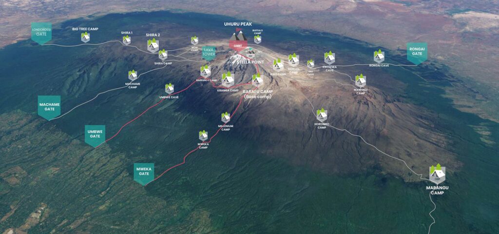
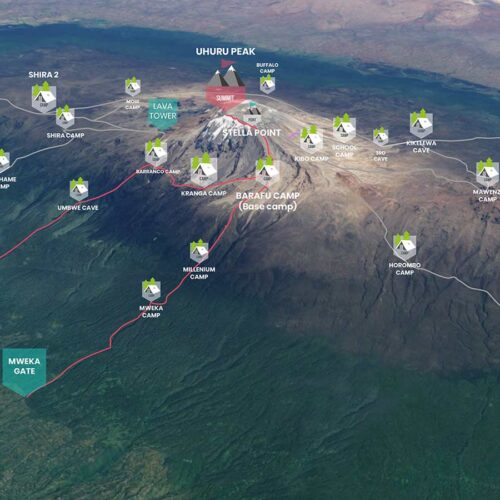
Approaching from the south, the Umbwe route is a short, steep and direct climb. After reaching Barranco Camp, the trail turns east and traverses underneath Kilimanjaro’s Southern Ice Field on a path known as the Southern Circuit before summiting from Barafu. Descent is made via the Mweka route.
TREKKING PROGRAM
we offer best programs for adventure
Umbwe Gate to Umbwe Camp
Elevation: 5,249 ft to 9,514 ft
Distance: 11 km/7 miles
Hiking Time: 5-7 hours
Habitat: Heath
The day begins with a 50 minute drive to Machame Gate where registration formalities will be completed. We then transfer through villages and coffee and banana plantations to Umbwe Gate. The trail ascends sharply on a forestry track which winds up the dense rain forest. The path narrows and steepens as we climb the ridge between two rivers surrounded by huge trees. Umbwe Camp is perched between trees and thick undergrowth.
Umbwe Camp to Barranco Camp
Elevation: 9,514 ft to 13,044 ft
Distance: 6 km/4 miles
Hiking Time: 4-5 hours
Habitat: Heath
The second day of the trek follows rockier terrain with sparse undergrowth and straggly, moss-covered trees. As we gain elevation, glimpses of Kilimanjaro can be seen. The path flattens as we approach Barranco Valley. From Umbwe ridge, the route descends to Barranco Camp through the strange but beautiful Senecio Forest.
Barranco Camp to Karanga Camp
Elevation: 13,044 ft to 13,106 ft
Distance: 5 km/3 miles
Hiking Time: 4-5 hours
Habitat: Alpine Desert
We begin the day by descending into a ravine to the base of the Great Barranco Wall. Then we climb the non-technical but steep, nearly 900 ft cliff. From the top of the Barranco Wall we cross a series of hills and valleys until we descend sharply into Karanga Valley. One more steep climb up leads us to Karanga Camp. This is a shorter day meant for acclimatization.
Karanga Camp to Barafu Camp
Elevation: 13,106 ft to 15,331 ft
Distance: 4 km/2 miles
Hiking Time: 4-5 hours
Habitat: Alpine Desert
We leave Karanga and hit the junction which connects with the Mweka Trail. We continue up to the rocky section to Barafu Hut. At this point, you have completed the Southern Circuit, which offers views of the summit from many different angles. Here we make camp, rest and enjoy an early dinner to prepare for the summit day. The two peaks of Mawenzi and Kibo are viewable from this position.
Mweka Camp to Mweka Gate
Elevation: 10,065 ft to 5,380 ft
Distance: 10 km/6 miles
Hiking Time: 3-4 hours
Habitat: Rain Forest
On our last day, we continue the descent to Mweka Gate and collect the summit certificates. At lower elevations, it can be wet and muddy. From the gate, we continue another hour to Mweka Village. A vehicle will meet us at Mweka Village to drive us back to the hotel in Moshi.
MORE PROGRAMS
we offer best programs for adventure
Ask a Quotation
Contact us to get Super planned Safari for your Holiday
Address :
Arusha,Tanznia
City :
Arusha
Email :
info@tremendoussafaris.com
Phone :
0758 840 793
